Search This Blog

Monday, September 10, 2018

Piute pass


Piute pass trail starts at the North lake parking lot. It is 11 miles and 2300 ft, out and back. It goes through forest along a stream before gaining elevation into a high valley of several lakes. There are a lot (about a 1000)  of high steps on this trail. The steps are the most distinguishing feature on this hike.


 This is the second stream crossing. It has a good foot log.


This is the first stream crossing. It has a foot log too, but it is not very level. The water was low enough to get across on rocks.


 After the hike through the woods we reached Loch Leven lake. The first lake in the valley. The pass can be seen in the distance. It is a very gentle grade to the pass, but there are the steps.


 Magenta paint brush.


 Alpine Gentian


 Sierra Gentian


 Large Monkey flower


 Large Monkey flower.


Red and white ridgeline along the trail. The end of this ridge is where the parking lot is.


 The final few steps at Piute pass.


 View of Summit lake from the pass


 Looking back at Piute lake and Loch Leven lake. And other un-named lakes.


 One of the un-named lakes surrounded by grasses.


 Red Heather


 Some of the 1000 steps.


 Kay gets credit for this photo because she saw it first and everyone just copied her. It is loch Leven lake.


Sticky Cinquefoil

Mono pass hike

Mono pass trail is about 8.5 miles and 2000 ft out and back. It reaches an altitude of 12,000 ft at the pass. It starts at the Mosquito flat trail at the end of the road that turns off of 395 north of Bishop at Toms Place.


 The trail follows Little Lakes Valley for about a mile before coming to this trail junction. The Morgan pass direction goes up the valley to Long lake, Gem Lake, and Chicken foot lake.


 The view up little lakes valley toward the other lakes.


 We continued up the Mono pass branch and came to the Ruby lake cutoff.


 Ruby lake is very nice.


 The ridge above the lake is impressive. We continued up the switch backs toward this ridge but cut right into a canyon leading to the pass.


 Up the switchbacks looking at Ruby lake.


 Close-up of Ruby lake showing Kays group of hikers looking up at us on the switchbacks.


 At the top of the switchbacks before the right turn into the canyon toward the pass.


 Nearly to the pass looking back toward where we came from. This is the same location as the cover photo of my blog that was taken in June about 2 years ago. The snow was much deeper then.


 This is all the snow remaining.


 Just over the pass the trail continues out a ridge on the left to a viewpoint into the next canyon. It is very barren at this elevation.


 The small summit lake below the ridge that has a view into the next canyon.


 The view into the next canyon.


 Our lunch spot.


 Group shot with next canyon in the background.


 Interesting mountain with distinctive snow patch remaining.


On the way back, near the pass we saw the only flowers at this elevation. Rock Fringe.

Baboon lake hike,via Blue lake.


Baboon lake is above Sabrina lake on a 9.5 to 10 mile out and back. It gains about 2300 ft and part of it is on a little traveled use trail.


 After leaving the trailhead near the Sabrina lake dam we hiked along the lake till the trail turned up toward Blue lake.


 View of Sabrina lake in the morning light.


 Soon we entered the John Muir wilderness.


 First stream crossing


 After the trail turns uphill there are many sections where it is paved with granite cobblestones.


 View from a high bench before blue lake.


 Looking back to Sabrina lake from that bench.


 Upon arrival at Blue lake the trail crossed these logs instead of turning right where it looks like the trail should go.


 Then you come to a good break spot on the edge of the lake.


 Continuing along the lake you come to the trail to Dingleberry lake but bear left toward Donkey lake.


When you are halfway past Blue lake a signpost sends you on the unmaintained trail to Baboon lake.


 Part of the unmaintained trail just before reaching Baboon lake. The trail actually comes out at a point above the lake, and above 11,000 ft, so we didn't go down to the shore.


 Also along the way to Baboon lake you get a view of Donkey lake below.


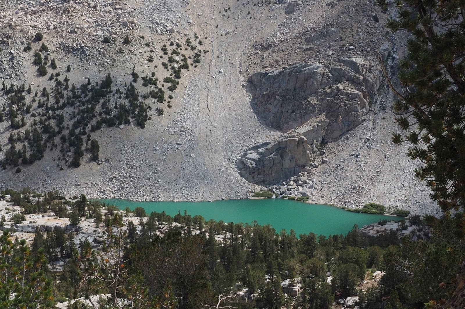
 First view of Baboon lake. There are other lakes behind it that you cannot see.


 The sun came out a little to bring out the color in the lake.


 An interesting pine tree at the lake overlook.


 On the way back when we reached to junction with the main trail we took a half mile detour toward Donkey lake to see a water feature where we had taken our lunch break last year on the Blue lake hike.


 In is a place where a stream cascades over flat granite slabs creating pools.


 On the way back to the car you can see a red ridge where we will hike by when we go to Piute pass in two days.


Looking back where we cam from some weather was coming in.