
This is a new loop that goes thru the escarpment and circles back
through another gap in the rocks.It is about 4.5 miles and 800 ft gain. It goes near Brians Big Wall but is named because of the many big walls there.

through another gap in the rocks.It is about 4.5 miles and 800 ft gain. It goes near Brians Big Wall but is named because of the many big walls there.
.jpg)
It starts at the gated road that leads to Duck Rock. After walking about halfway up that road we turned west at this point and headed toward the slight gap in the ridge straight west. Upper right quarter on the screen.
.jpg)
.jpg)
After passing over that ridge you are in a narrow wash that has this low arch. Behind the arch is a ridge of smooth rock that you climb over and bear left to reach the 3 man (or 3 turtle) petroglyph
.jpg)
.jpg)
When looking at the petroglyph there is a small wash to your right. About 100 feet down this wash, and before you have to climb over a rock fall, high up on the right is this formation.
.jpg)

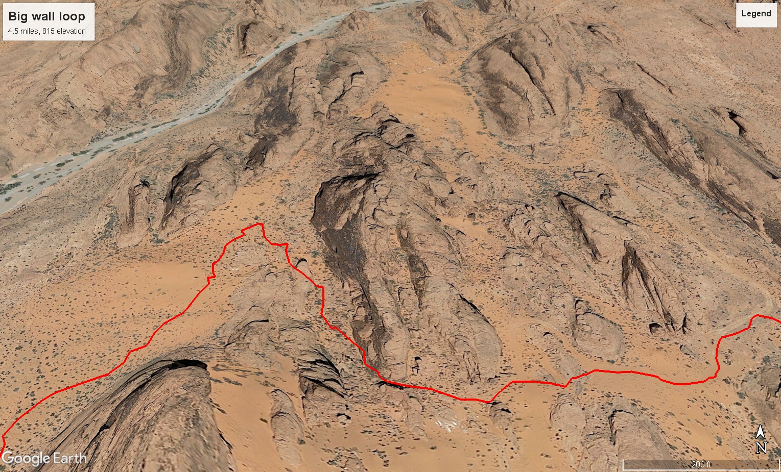
Map of the sandy alcove where the petroglyph is and the side trip down the wash where the rock formation is. Including the dip in the wash where the low arch is.
.jpg)
From there head west generally following the easiest path toward any gaps you may see in the rocks
.jpg)
This is the first narrow gap you will come to. Just through it bear right and get onto the high ground so you can see further west toward a sandy area with possible tire tracks from offroad vehicles.
.jpg)
Go up the sandy hill toward the big wall where you can find a gap to pass through.
.jpg)
At the top of this sandy climb, and to the right of the big rock face, is a gap leading to the other side.
.jpg)

This is climbing down through that gap to the rare Winnebago w/toad petroglyph. On your right when it flattens out.
.jpg)
.jpg)
A hobbit house near the petroglyph.
Map of the area. Thru the gap and along the wall on the right to see the Winnebago.
.jpg)
Same wall. Hobbit house to left, petroglyph to the right (center). Too small to see from here. This is one of the Big Walls
.jpg)
Then you walk east and south over dunes and parallel to the back side of the escarpment till you come to a likely place to cut back through the escarpment. It looks wide open at first but you might have to backtrack a few times.
.jpg)
.jpg)
Cooper Dogweed i believe.
.jpg)
Bush penstemon
.jpg)
A bighorn looking at us
.jpg)
5 More bighorns
.jpg)

We followed washes generally east and were led to the top side of this crack where we had to backtrack to find a way around. A good scrambler could go through if they didn't get stuck.

Map showing the backtrack loop, and the rest of the route to Magnesite wash where it goes north before turning east to Duck Rock.
.jpg)
There were several dry falls that needed going around.
~2.jpg)
.jpg)
.jpg)
.jpg)
.jpg)
.jpg)
.jpg)
This is one of the dry falls that empties into a larger wash right at the bottom of a ramp that leads back to the Vishnu Temple where we should have come down if we had gone just a little left of the track we took.

Bones at the junction of the wash
.jpg)

Just when you think you are finished with dry falls, you come to this small one that would be easy if not for the water you would fall into if you go straight. Can be gone around on either side. Depneding on water level.
.jpg)
Easy walking at last.

Only minor ledges from now on.
.jpg)
Cool rock
.jpg)
.jpg)
.jpg)
When I reached the final wash (magnesite wash) it goes north to Duck Rock. I instead continued east over land to where the car was parked.