This was our first trip to explore Cedar Mesa. We planned 5 nights in Bluff to see many of the local ruins and pictographs.
Cedar Mesa is the main plateau in the Bears Ears national monument that trump reduced by 85%. it is west of Bluff and Blanding.
On our way to Bluff we pased through Monument valley. The Loop drive through the valley on the
dirt road was closed.
Famous Mexican Hat rock near Mexican Hat.
View from the balcony of our hotel in Bluff.
Close-up of the same rock showing bullet holes. I have a new tele lens.
Moon on the first night with the new lens.
Our first day we drove a few miles west of Bluff to the Lower Butler wash road and drove north. We planned on seeing many of the sights along this road. There are too many to see in one day. This section of Cedar Mesa is still within the reduced size national monument. All canyons off Hwy 261are not.
First, a small ruin near the Wolfman petroglyph. This is visible from the canyon rim before
dropping down to the pictograph.
Some say that this is the "Wolfman". No proof of it.
The petroglyphs here are very well done. I used photoshop to remove the bullet holes in this one
and then next one.
This is the main panel here. It might the Wolfman too. There are definitely wolf prints here.
Saw this small Phacelia on the way back to the car. It was about a 2 mile hike with a short scramble into the wash on a ramp.
Wild Onion in bloom
Our next hike was up the road was to find the "Big Crane" petroglyph. I had some internet directions but had never been there. It was also about a 2 mile RT hike.
t is the only petroglyph in the area and is about 2 feet high.
Small Lupine on the way back to the car.
I am told that this is a rare white Bluet. The common Bluets here are pink but we didn't see any
of them.
Small flower Fish hook cactus.
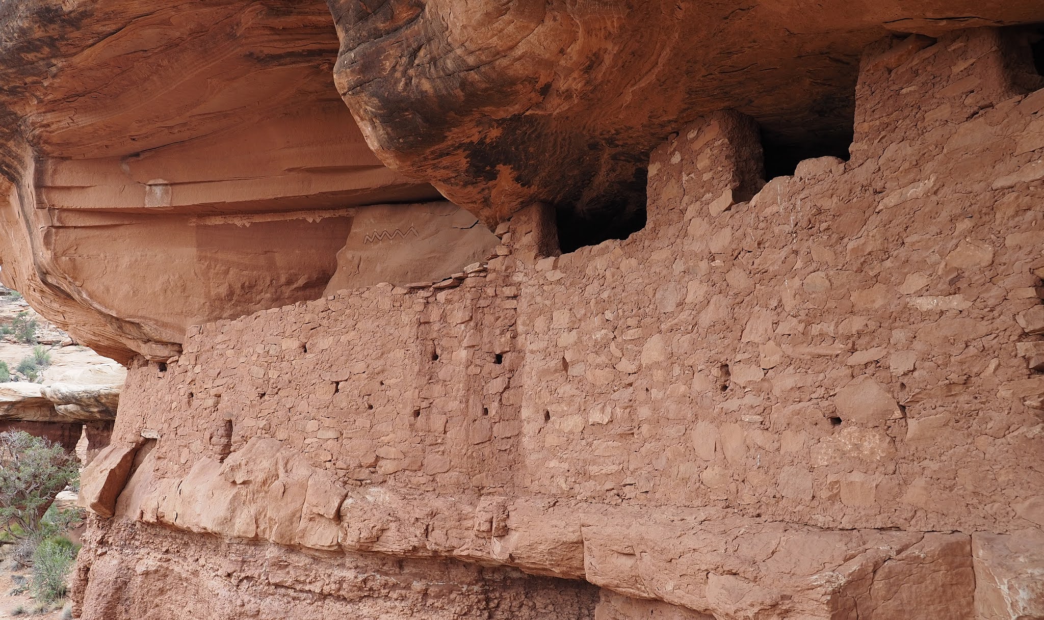
Our next stop on the road was to Double Stack ruins. It is also about a 2 mile hike to a ruin in the alcove you can see about half way in. There are two ruins. One at ground level and another above it on an impossibe ledge.
The alcove where the ruin is.
Utah Penstemon
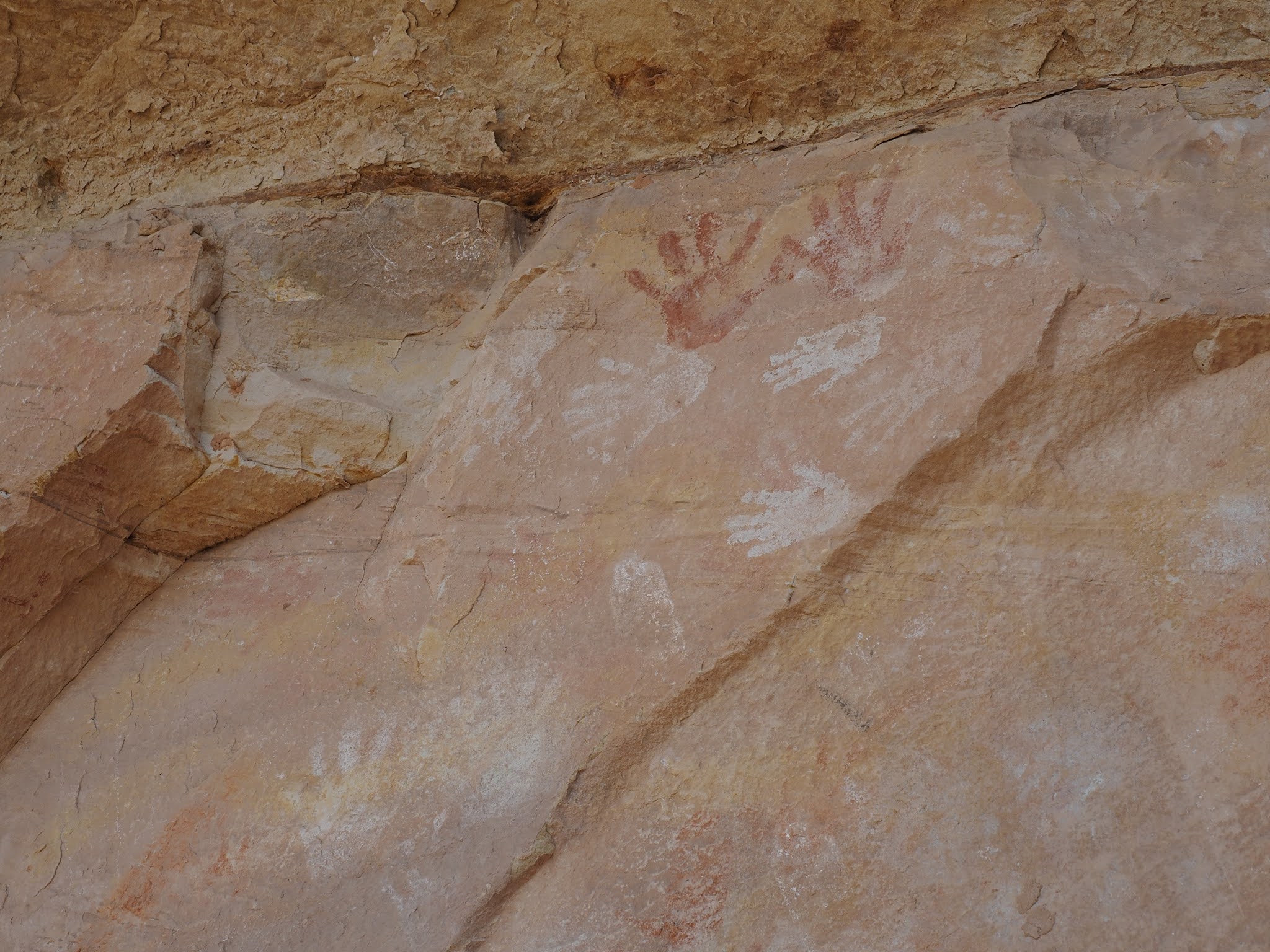
Hand prints in the lower ruin.
Stone work in the lower ruin
Upper ruin would need a 50 foot ladder to get to
Eastern Collared Lizard showing its long tail. It is a lizard that can run 16 mph on it's hind legs.
On the north end of the Butler wash road are some signed dinosaur tracks. The dirt road was about
26 miles long and had about 8 different hikes we could have done. We only did 3 of them. I
believe the road would be passable in a 2wd vehicle in good weather.
Interesting rocks just above the dinosaur tracks.
On our way back to Bluff we drove the Moki Dugway which is a unpaved section of the road descending about 1000 feet in 3 miles off Cedar Mesa and giving a view of Valley of the Gods below. The drive through Valley of the Gods is 17 miles of maintained dirt but some low clearance cars might not make it. Subaru had no problem at all.
It is like a smaller, and free, Monument Valley. And it was open. The scenic loop through
Monument valley is still closed due to Covid.
The next day we went to House on Fire ruin. Still within the Monument. It is about a 2.5 RT mile hike along a wash in Mule canyon.Then, The Citadel was next on the agenda.
House on fire with a wide angle lens.
Showy Stoneseed
The Citadel is on Cigarette Springs road, off hwy 261, and is no longer in the reduced national Monument. The road is very rocky and slow going.
On the trail to the Citadel you get an overlook to 7 Kivas. You can see a couple of them in this
photo. There was one ledge on the trail where we needed a hand strap to get back up.
The Citadel is on a peninsula that is hard to get to. Not to mention the rocky road leading to the trailhead. This is a point where the exposure became too great for us and we turned back. The ruins are out on the peninsula on the right side not visible from here. It is like the 3 steps of death on the Top of the world hike.
Long shot of someone on the bridge to the Citadel.
Townsends Daisy I believe.
Another Eastern Collared Lizard with more color.
These are the Butler wash roadside ruins. Still in the Monument. About a one mile walk. There are
other Butler wash ruins up the wash about a half mile east of this roadside attraction.
The Next day we had a permit for Moon House which allows only 20 permits per day. It is 9.2 miles out Snow Flat road, again off hwy 261, and outside the reduced monument boundary. Snow flat road is very rocky in places. It took and hour to drive the 9 miles in a subaru. A truck or jeep could drive faster but you would want off road tires. Not much sand, just slickrock with small ledges.
The trail is very short from the parking lot to the rim maybe 500 feet, then down into the canyon and up the other side. Loss of about 300 ft and a gain of about 150 feet on the other side. Both steep. Photo is looking across while going down. There was a pour over soon after starting down that had a good pile of rocks to assist going down. Going back up hand holds were a problem, but we had a rope for those who needed it.
There is a pictograph here too.
Usually, you do not touch, or climb on ruins but this one has a wall in front of the actual ruins that they allow you to carefully enter ( 4 people at a time).
Behind the wall. There is a white stripe on the wall and it is also repeated inside the room which is
very dark and hard to photograph through the door, There is a "moon" on the stripe inside the
room giving the site it's name.
Here is the Moon. Taken with Pixel phone using Night Sight mode. Sticking my hand through the
door without looking.
Many little peep holes in the outer wall.
Up canyon and down canyon on the same bench are other ruins that we didn't walk to because the
weather was looking bad for the drive out.
One of the ruins down canyon with the tele lens.
Bottom of the canyon. The trail came down by the large rocks on the left, and back up at the close
end of this flat slickrock section. The hoodoo above is where the ruins are.