We finally were able to obtain a permit for the Wave after applying online for 32 straight months. The timing was good because the coronavirus has closed the in person application system making the only option the online version. This effectively limited the number of people there that day to 10 instead of the usual 20. However we didn't see anyone all day long.
We stayed the previous night in Kanab in order to get an early start (4:00 AM). We started hiking 30 min before official sunrise.
The trailhead is 40 miles east on Kanab and 8 miles down House Rock Valley road. The trail starts across the road from the parking lot. There is a Kiosk to sign in, and a box to pay the fee if you are hiking Wire pass, or Buckskin gulch that don't have a quota but do have a fee. It is very close to 2.5 miles to the Wave. We explored most of the area and our overall track was 7 miles with approximately 1000 feet of cumulative gain. Starting at 5:42 AM and finishing at about 1:15.
The trail follows the wash east up on the flat benches to avoid the twists and turns of the wash. To hike to wire pass you are supposed to walk in the wash. After 3/4 of a mile the trail cuts up a hill on the right leaving the wash forever. This is the sign where the trail to the wave leaves the trail to wire pass.
The trail then crosses a wide sandy hill heading toward the rocky ridge you see here. You have to cross that ridge at a low pass that is in the left portion of the frame aligned with a dark pointed juniper tree. It is a low notch in the ridge. Do not be tempted to go a little further to get around the end of the ridge.
This is the second trail marker we saw. It is where the trail crossed a wash just before the rocky ridge. You have to go left following the ridge to get to the notch where you scramble over. There is no sign or cairn there at the start of the climb but is a sign at the top (far side) of the notch.
When you get to the top of the notch there is this sign that means keep right and stay up on the slope without dropping down. From here you can see the next trail sign in the little pass on the right side of the screen. It is higher than you are now and is the reason for not loosing elevation.
This is the same shot zoomed in a little. I think you can see the trail sign just left of the round juniper tree on the horizon.
About this time the sun was up and lighting up the ridges.
This is the trail sign just past the one on the ridge I mentioned before. It points to Twin Buttes, the halfway point, and a major landmark because this is where the trail signs stop because you can see the wave from the Buttes. The wave is in the light gray mesa directly behind the left of the buttes. Pass the Buttes on the right, staying high on the rock. From the wave you can also see the twin Buttes as a target on your way back.
Tree in front of Twin Buttes.
Looking back to the Twin Buttes. We tried to stay on rock but sand got in the way. There is some more rock to walk on later. The idea is to stay to the right on rock as long as possible while heading toward the vertical crack that marks the wave.
Interesting Shark Fin rock on the ridge on the right that you pass by.
Here you can easily see the vertical crack in the mountain in the distant center that marks your destination. Now you descend toward a sandy wash, cross it, and slog up a sandy hill to the wave.
Slightly closer. Follow the yellow flowers (Utah mules ears) to a gap in the dunes, downhill and across toward a low band of redrock. Go up the sand to the left of the band of red rock, or directly up the rock toward the shaded band of the cliff where you might be able to see the "U" section that is highlighted in the sun. That "u" section is the entrance to the Wave. If you aim to the left of the actual entrance you can follow a wall to it.
Opposite from the wave and to the right of the trail you have been on.
This is a rock of the left of the entrance to the wave. From it you follow the wall to the right to the actual entrance. It might be a good idea to explore around this rock because Google Maps mark it as a mini wave.
Step up this small bench and into the wave entrance.
Turn left before the bush to enter.
Left wall of the entrance.
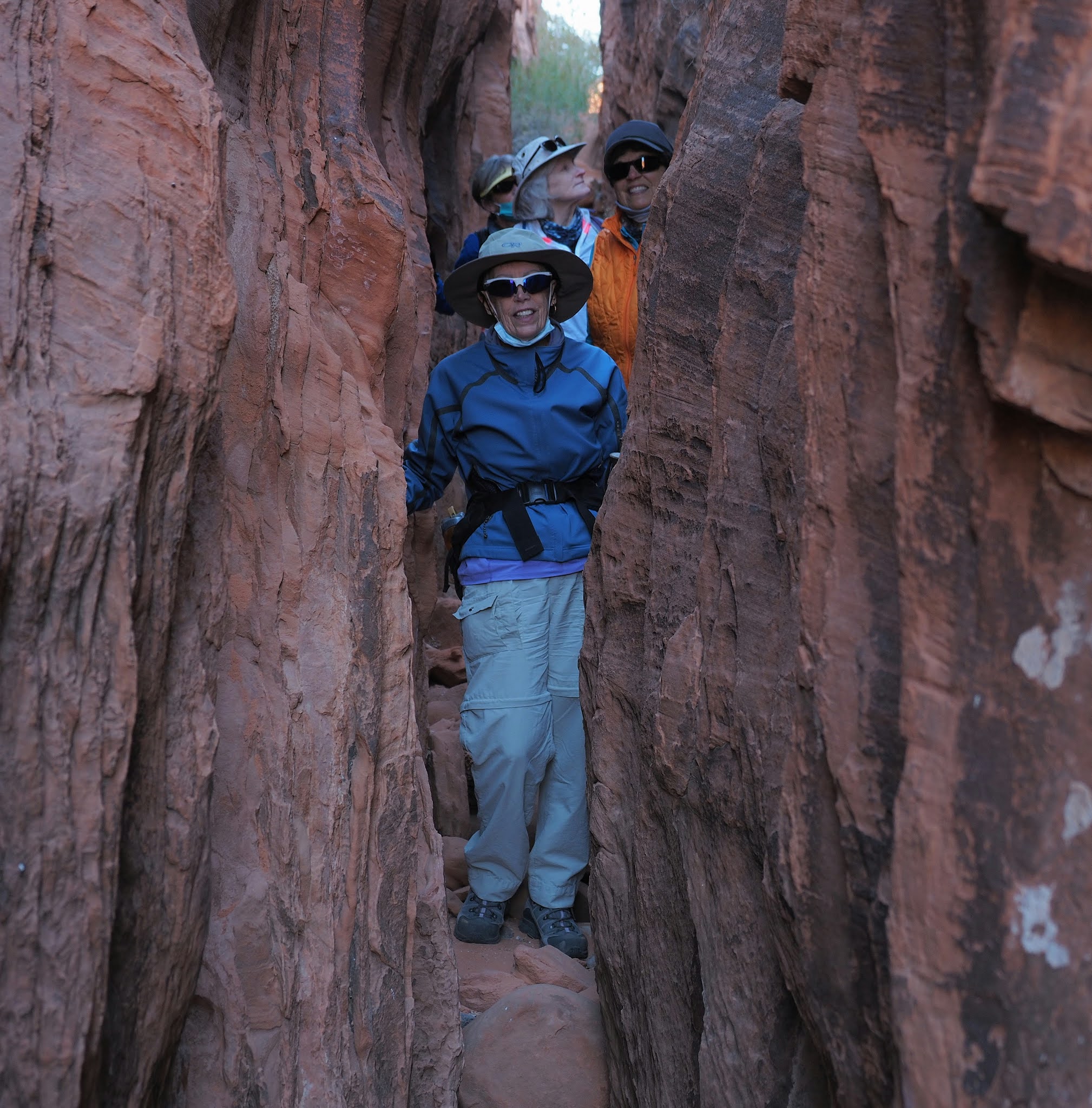
Looking back to where we entered the wave. Just walk straight and you will be in the middle of the wave. There, on the right is a little slot for pictures, and to the left is the climb out of the wave, and the place to look back to take the Iconic wave photograph. From where Brenda is standing you can look back and see one of the Twin Buttes.
This is looking back from the middle of the wave to the entrance, around the corner on the right where Brenda was just standing.
In the little side slot.
In the little side slot.
The little side lot is on the left around the corner.
Looking up out of the wave toward top rock arch. We didn't get all the way there. But from there would be a great aerial shot of the wave.
This is the ridge to the right of Top rock arch. That would be the route you would follow to get there. We went up there but turned right to see the Alcove and Melody arch and window. When you are below the Top Rock arch, the idea is to first follow the relatively flat bench around to the right to a rock called the Second Wave.
The second wave. Usually photos are taken from the other side but this early this is where the sun was.
To the left, up hill, is the "path" up to top rock arch, the Alcove, and Melody arch. It is a hands and feet climb very similar to the climb up West Clark Bench from Edmaier's Secret.
Looking down from the general area.
On the way to The Second Wave you pass this yellow rock area.
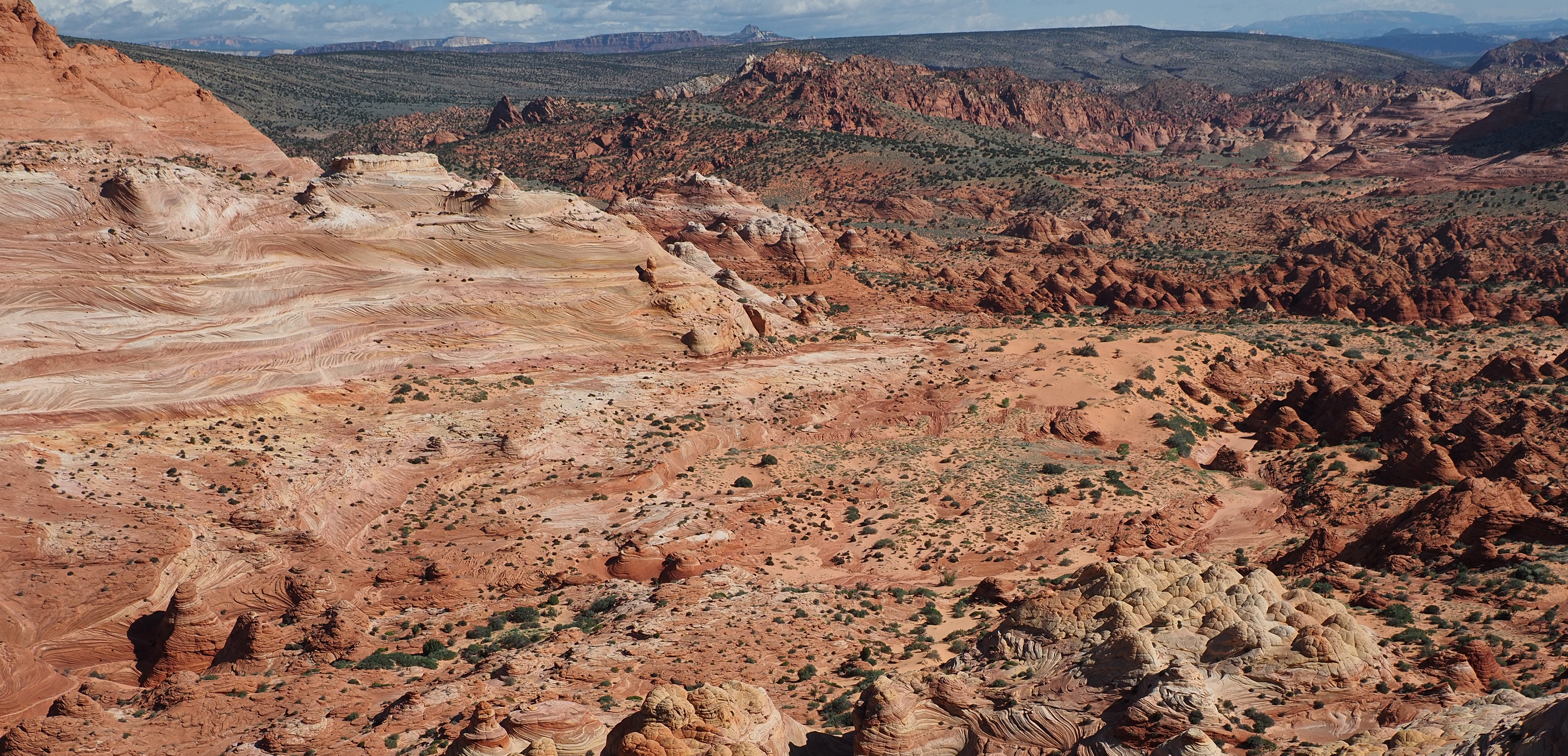
View from up high looking back the way we came. You can just see the right most Twin Butte in the middle distance about 1/4 down from the top. It has a small white top. The way back to the car would go close to the rock ridge on the left while avoiding the large sandy area on the right. Right down the middle and between the Twin Buttes and higher ground. Stay high to the left to find the notch in the rocky ridge that had the trail sign. We missed that notch, but it doesn't matter because you can see the sandy path on the other side of the wash we earlier crossed.

Back to the trail we followed to the Alcove. At the top of the steep climb behind the Second Wave we traversed right around the castle like peak and reached the alcove easily. Go into the alcove and explore the big dune. When exiting the Alcove traverse left, staying at about the same elevation following the high ground on your left. After only about 500 feet there will be a notch high on your left that you can walk through without trouble. That is the entrance to Melody arch alcove. Come back down the same way and continue the way you were going, past a sandy basin with large pine trees, and on down to the back side of the entire Wave escarpment. Follow the back side north to rejoin the trail you can in on.
Brenda at Melody Arch.
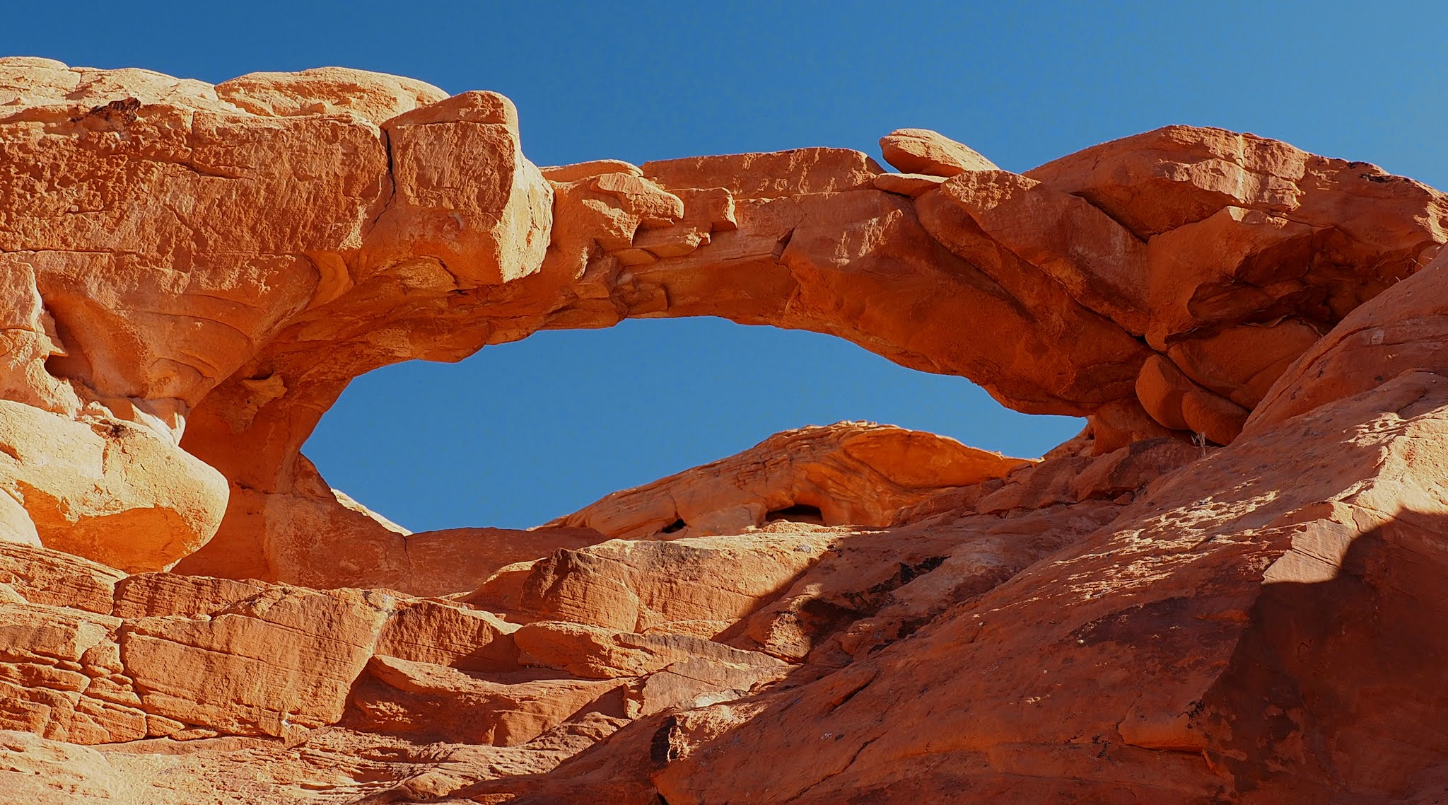
Looking out the Window. It is about 300 feet above the valley. Big Mac rock is visible from the window.
Big Mac from the window.
See the Window in the ridge?
The Window by Melody Arch.
Looking North along the backside of the Wave escarpment. The small knobs at the end are where you go left to find the trail you came in on.
West Clark bench on the other side of Buckskin gulch....You cant get there from here.
Returning to the wave to get a photo without a shadow. This is about 11:00 AM Utah time. All photos in the wave were wide angle shots. 14mm equivalent.
Clouds started building making us hurry back to the car to get out of the road before it became impassible. It turned out that only a few drops hit us. There was some snow and hail mixed with the rain. Not enough to completely wet the ground, but that was enough to make the surface of the road slippery. If it had rained enough to wet the entire road it would have been a different story.
Detail of the route up the rock
Detail of the Alcove and Melody arch


