The first week of May we went to Bluff to explore Bears Ears with a few friends. We stayed at La Pintada Posada for 5 nights which is our favorite lodge in Bluff.
On the drive over we went thru Mexican Hat.
Tuesday our first hike took us west of town about 4 miles to the Airport turnoff. There a short dirt and rick road leads to the edge of lower Butler Wash. The trail down the wash os well marked and the sites along the way are obvious due to use trails.
The trailhead is an area of slickrock on the edge of the canyon. There was an old road leading down into the canyon that was easy to follow.
View down into the canyon
Some wildlife spotted on the way
A small ruin on a ledge on the way down the wash
Grinding groves at the ruin
 a kind of petroglyph I hadn'n seem before.
another phacelia
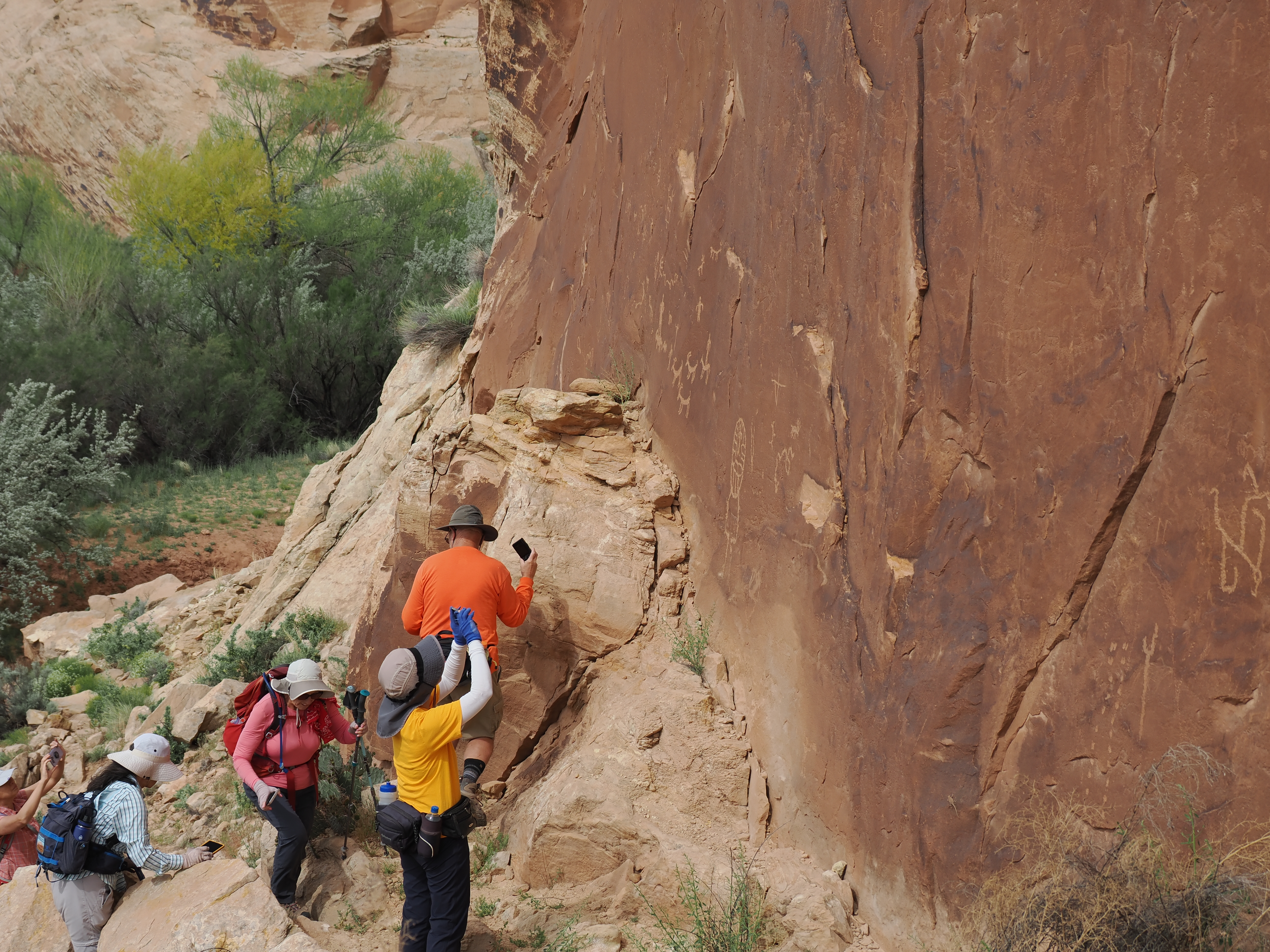
When we reached the mouth of the canyon at the San Juan river there were more petroglyphs around the corner.
These were on the vertical wall. Hard to understand how they were used.
Utah Penstemon on left and Eatons Penstemon on right.
IN the bedrock of the wash was a figure sometimes called the Pig. There were supposed to by carved wolf tracks there too but we couldn't find them.
Very rare plant found on the slickrock where we parked. Phemeranthus Brevifolius
From there we went to the Sand Island petroglyphs. Both lower and upper panels.
The next day was the hike to the Citadel. We had tried to get there last year but were turned back by extreme exposure. This time it wasn't so bad. We had a rope just in case.
On the way along the rim is an overlook into the 7 Kivas ruin. this is from the overlook.
The Citadel is located out on this peninsula on the right out of sight.
There was some scrambling on the way out there.
Balanced Bear Faced rock at the Citadel.
The last little scramble up to the ruin
Looking inside one of the rooms
The tricky part with exposure.
The famous Bears Ears which the monument is named for
On the way back the 7 Kivas were in shade and I could see all 7 of them
The view into the Valley of the Gods at the foot of the Moqui Dugway.
The next few slides are in the Valley of the Gods.
The next day we visited the sites along the West Side of Comb Ridge.
Mariposa lily
This is the ruin at Wolfman Panel that you can see from the edge looking down.
The ramp down to the Wolfman panel
Next we came to the trailhead for the Big Crane panel
It is located on the shaded ledge near upper center of the photo
It is pretty cool and no other petroglyphs are there.
Very full claret cup cactus
Our next stop was to see Double stack Ruins but we went up the wrong canyon and found this 3 window alcove.
We were able to hike over the top to the canyon where Double Stack is located and see it from on high.
Looking down on the lower Double stack ruin
Looking across to upper Double stack which is on a high inaccesible ledge.
After Double stack we headed to Monarch Cave ruins
Small flowered fish hook cactus
First view of Monarch Cave. Most of it is roped off so you can't get close.
On the last day we went to House on Fire and to Natural Bridges national monument
More hand prints at House on Fire.
Brick work at House on Fire.
House on Fire as it appears in photos. It really doesn't look like this.
A wide angle cellphone shot of house on fire.
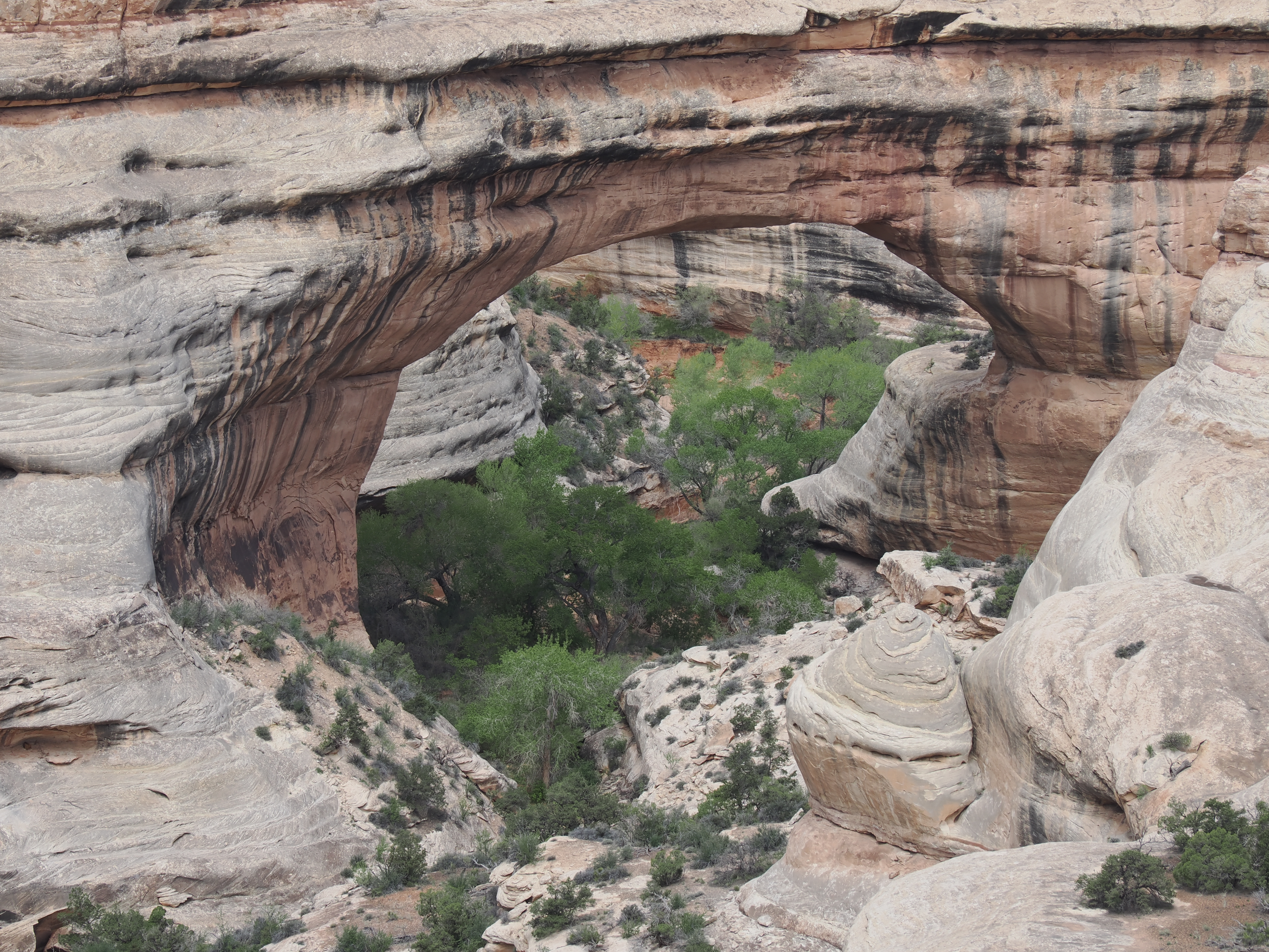
Then we headed to Natural Bridges to hike to Sipapu bridge and see the others from the viewpoints.
Sipapu bridge. The largest in the park.
The trail down was well constructed with stairs, steps, and ladders.
Horse collar ruin as seen from the overlook
Same area as Horse Collar
The last bridge.
On the way home Monument Valley in morning light
Milkvetch on the side of the road.
We took a side trip to get a photo of Betatakin ruin at Navajo National Monument.
You can only see it from a far away high overlook. Unless you take a Ranger Walk which I'm not sure they do anymore.
Hogan and sweat lodge exhibit.

.jpg)
.jpg)
.jpg)
.jpg)

.jpg)
.jpg)
.jpg)
.jpg)

.jpg)
.jpg)
 a kind of petroglyph I hadn'n seem before.
.jpg)
.jpg)
.jpg)
.jpg)

.jpg)
.jpg)
.jpg)

.jpg)

.jpg)


.jpg)
.jpg)
.jpg)

.jpg)

.jpg)
.jpg)
.jpg)
.jpg)
.jpg)

.jpg)

.jpg)
.jpg)
.jpg)
.jpg)
.jpg)

.jpg)
.jpg)
.jpg)
.jpg)
.jpg)
.jpg)


.jpg)

.jpg)

.jpg)
.jpg)
.jpg)
.jpg)
.jpg)


.jpg)
.jpg)
.jpg)
.jpg)
.jpg) This is the ruin at Wolfman Panel that you can see from the edge looking down.
This is the ruin at Wolfman Panel that you can see from the edge looking down.
.jpg)
.jpg)
.jpg)
.jpg)
.jpg)
.jpg)
.jpg)
.jpg)
.jpg)
.jpg)

 It is located on the shaded ledge near upper center of the photo
.jpg)

.jpg)
.jpg) We were able to hike over the top to the canyon where Double Stack is located and see it from on high.
We were able to hike over the top to the canyon where Double Stack is located and see it from on high..jpg)
.jpg)
.jpg)
.jpg)
.jpg)
.jpg)

.jpg) Small flowered fish hook cactus
Small flowered fish hook cactus.jpg)

.jpg)

.jpg)
.jpg)
.jpg)
.jpg)
.jpg)
.jpg)
.jpg)
.jpg)
.jpg)
.jpg)

.jpg)


.jpg)
.jpg)


.jpg)
.jpg)
.jpg)

.jpg)
.jpg)

.jpg)


No comments:
Post a Comment