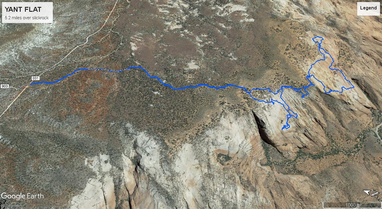
Yant Flat is an area of sandstone about 12 miles northeast of St George UT. Take exit 22 off I 15 and drive 1.5 miles to the next exit where you can cross under the highway on Silver Reef road headed north. From the underpass it is 10.4 miles (at 3.1 miles take a left fork) to the parking area directly across from a side road going north (FR903). The trail goes south at a restricted area sign prohibiting vehicles. It used to be a road but is mostly a sandy trail now. Reach the edge of the sandstone in 1.5 flat miles, or 30 minutes.
This is the last section of the trail just before arriving at the sandstone area. From here you drop into the sandstone basin and wander around all you want. We did 5.2 miles total including the 3 miles of trail (RT) from the car.
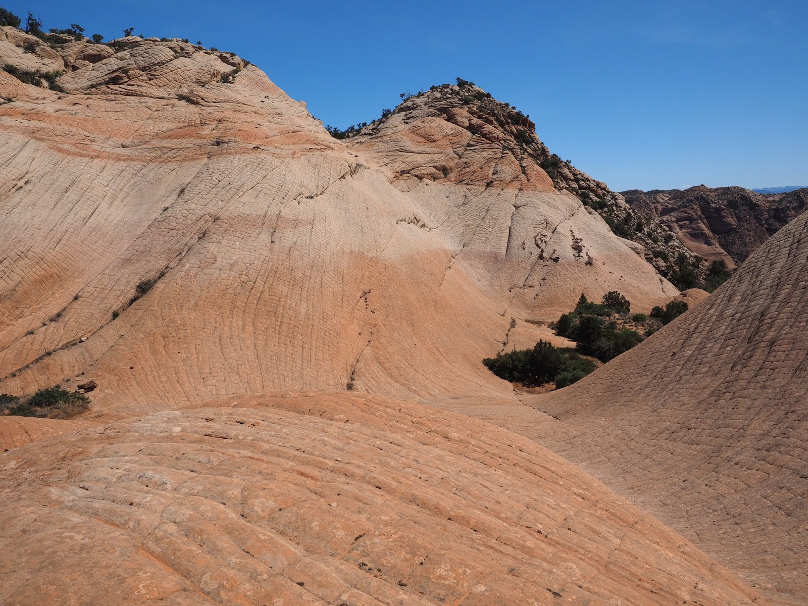
This is the first view into the basin. We went left, then right finding the easiest way down avoiding the steepness straight ahead. We wanted to explore the edges of the basin on the right before cutting left to see the rest. At the far edge there is a big drop off to a canyon below.
Here we are switchbacking down into the basin
This is looking back up the steeper area we skirted on the way down.
Following the fall line to the right we were coming to a drop off where we turned back.
Nice texture and color in the rocks
Just before the drop off there were several pools.
Panorama of the first basin Click on the link, then on the photo. You can move it around with your mouse.
From the turn around point we traversed back across the areas we missed on the way down and headed toward the trees on the ridge where a short trail leads along the escarpment to a second sandstone basin. There are 4 or 5 separate sandstone areas. Two to the left, and two to the right. We just explored the two middle, and most scenic ones.
Getting closer to the ridgeline. When we reached the ridgeline we followed a sandy trail to the right, and the second sandstone basin.
Unusual to see Rock Mat blooming on sandstone instead of the limestone like it does on Mt Charleston.
First view of the second sandstone basin.
We explored this basin in a counter clockwise direction too.
Our first counterclockwise leg heading toward the right edge of the basin where there is a big drop off.
The edge of the drop off.
Just above the rock and to the left is a shadow with a small group of small trees. It is visible from the top of the ridge looking right. It is a small basin where dirt and water accumulates allowing the trees to grow. From the top of the ridge it is the most prominent group of bushes. Go walk through the trees and drop down a small ledge and there are petroglyphs on the right about 20 feet past the ledge.
Continuing our counterclockwise exploration.
Another lookout. Sand Hollow recreation area in in the distance.
Unusual carving at the lookout.
Looking east in the direction we were headed.
PANORAMA OF SECOND BASIN
Three hikers to show the scale of the basin.
Scrambling on a small knob. There could be many scrambling opportunities here.
A small pond reflection.
One of our snack breaks.
First view of the White Stripe. The stripe is visible on Google Earth. We followed it till it got steep. The next sandstone basin is just past the rough ridge you see in the upper right.
Standing on the White Stripe. This is afternoon light. It is in shadow in the morning.
Only small arch we saw.
This is traversing back up out of the basin to get to the trail back to the car.
Last view of the basin.
We then continued east along the rim to explore the third basin.
Looking down into the third basin. We found a way down a red sand dune and I think it would also be the best way to come back too. Just go very slow up the sand on the way back.
Walking along the bottom of the basin.
Looking across the basin south to north.
At the south east side of the basin there is this smooth gray rock area you walk along like we are doing and when it ends scramble up to the top of the ridge/mountain on the right. At the south east edge of the highest point look down to Yellow top, and what I think is called the Candy Cliffs.
We left the high point going back the way we came and at the bottom of the basin we went across it and up the other side. That is when I decided the sand route might be easier....but if you want to scramble go any way you want.
This is looking toward the outflow of the third basin. It should lead down to canyon bottom but there might be steep places. We didn't try it this time. But if it turns out the be easy it might be the best way to circle around to yellow top that we saw from the high point.
On the way back to the cars we passed another large concretion sticking out of the rock in the second basin. The whole route through all three basins is likely 7 miles.
Entire track from the parking lot.
Details of the two basins we explored.


No comments:
Post a Comment